Canyonlands National Park Map and Entrances Explained
Planning a trip to Canyonlands National Park starts with understanding its map and entrances. Unlike many national parks with a single main entrance, Canyonlands is divided into four distinct districts separated by deep canyons carved by the Colorado and Green Rivers. Each district offers a completely different experience, and you cannot drive directly between them inside the park.
A Canyonlands National Park map helps visitors choose the right entrance, estimate travel times, and avoid the common mistake of assuming all attractions are connected by park roads. Whether you’re heading to Island in the Sky, The Needles, The Maze, or the rivers, knowing where each entrance is located will save you hours of driving.
Canyonlands National Park Map Overview
Canyonlands National Park covers more than 337,000 acres (527 square miles) in southeastern Utah. The park is divided into four separate districts:
- Island in the Sky
- The Needles
- The Maze
- The Colorado and Green Rivers
Although these districts appear close together on the map, there are no roads connecting them within the park. Travelers must exit the park and drive around via state highways to reach another district.
The two districts most visitors explore are Island in the Sky and The Needles, while The Maze is reserved for experienced backcountry travelers with high-clearance 4WD vehicles.
Canyonlands National Park Entrances Explained
Click the image below to view map of Canyonlands National Park in full size.
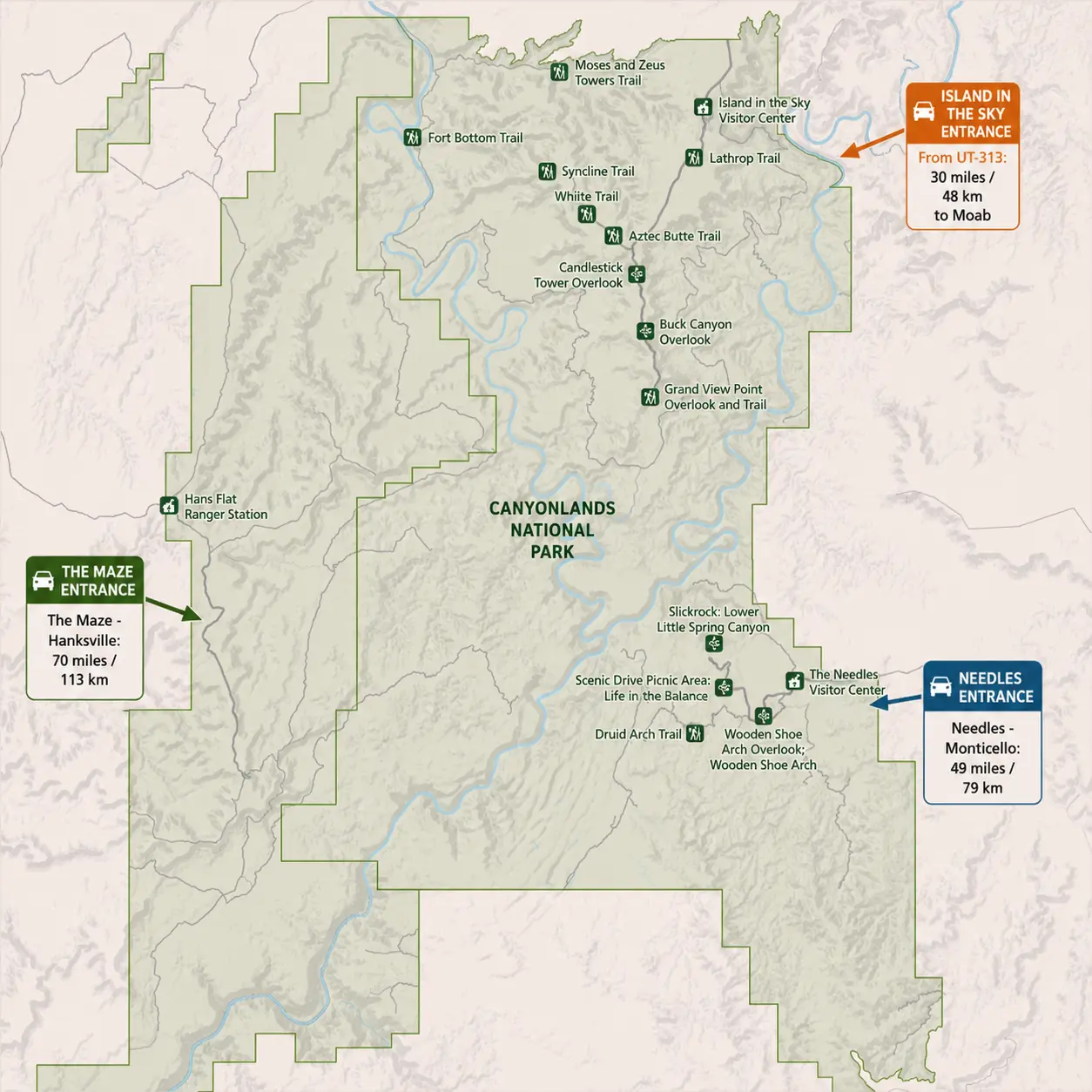
There are three primary road entrances to Canyonlands National Park, each serving a different district.
1. Island in the Sky Entrance (Most Popular)
Highway: UT-313
Nearest town: Moab, Utah
Drive from Moab: Approximately 32 miles (30–40 minutes)
The Island in the Sky entrance is the most visited gateway to Canyonlands National Park. It provides easy access to breathtaking overlooks and short hiking trails, making it ideal for first-time visitors and families.
Popular destinations include:
- Mesa Arch
- Grand View Point
- Green River Overlook
- Buck Canyon Overlook
- Shafer Canyon Viewpoint
- White Rim Overlook
The Island in the Sky Visitor Center is located just inside the entrance road.
This district is perfect for visitors with only one day to explore Canyonlands.
2. The Needles Entrance
Highway: UT-211
Nearest town: Monticello, Utah
Drive from Moab: About 75 miles (1.5 hours)
Located in the southeastern section of the park, The Needles entrance leads to colorful sandstone spires, longer hiking trails, and quieter campgrounds.
Highlights include:
- Chesler Park
- Druid Arch
- Elephant Hill
- Wooden Shoe Arch Overlook
- Big Spring Canyon
The Needles Visitor Center is near the park entrance.
Compared with Island in the Sky, The Needles offers:
- More hiking opportunities
- Less traffic
- Better backcountry camping
- Longer scenic drives
3. The Maze Entrance (Remote Access)
Primary access: UT-95 and remote dirt roads
Nearest services: Hanksville, Utah
The Maze is one of the most isolated regions in the entire National Park System.
There is no paved entrance road. Visitors typically reach The Maze through rugged four-wheel-drive routes beginning near UT-95.
Access requires:
- High-clearance 4WD vehicle
- Excellent navigation skills
- Extra fuel
- Water supplies
- Backcountry permits for overnight trips
The Hans Flat Ranger Station serves this district.
The Maze is recommended only for experienced adventurers.
Understanding the Canyonlands Map
One of the most confusing aspects of the Canyonlands map is the large distance between districts.
| District | Main Entrance | Visitor Center | Best For |
|---|---|---|---|
| Island in the Sky | UT-313 | Island in the Sky Visitor Center | Scenic overlooks, first-time visitors |
| The Needles | UT-211 | Needles Visitor Center | Hiking, camping |
| The Maze | UT-95 (remote roads) | Hans Flat Ranger Station | Backcountry exploration |
| Rivers | Boat launch access | None | Rafting and kayaking |
The Colorado and Green Rivers divide the park into separate regions, making internal travel impossible by regular vehicle.
Driving Between Entrances
Many visitors underestimate how long it takes to travel between districts.
Approximate driving times:
| Route | Driving Time |
|---|---|
| Moab → Island in the Sky | 35 minutes |
| Moab → The Needles | 1.5 hours |
| Island in the Sky → The Needles | About 2.5 hours |
| Moab → Hans Flat Ranger Station | 2.5–3 hours |
Always use a GPS or offline map, as cell service is limited throughout the park.
Which Entrance Should You Choose?
Choose Island in the Sky if you:
- Are visiting for one day
- Want iconic viewpoints
- Prefer short hikes
- Are traveling with children
- Want easy road access
Choose The Needles if you:
- Enjoy day hiking
- Want fewer crowds
- Plan to camp
- Have two or more days in the park
Choose The Maze if you:
- Have extensive backcountry experience
- Own a capable 4WD vehicle
- Want remote wilderness adventures
- Are prepared for self-sufficient travel
Tips for Using a Canyonlands National Park Map
Before your trip, keep these tips in mind:
- Download an offline map before entering the park.
- Do not expect to drive between districts inside the park.
- Fuel up in Moab, Monticello, or Hanksville before entering.
- Check weather conditions, especially if traveling on unpaved roads.
- Carry plenty of water, as services are limited.
- Allow extra travel time between overlooks and trailheads.
Frequently Asked Questions
How many entrances does Canyonlands National Park have?
Canyonlands has three primary road entrances: Island in the Sky, The Needles, and The Maze, each serving a separate district of the park.
Can you drive between Island in the Sky and The Needles?
No. There are no roads connecting the districts within the park. You must exit Canyonlands and drive around using state highways.
Which entrance is closest to Moab?
The Island in the Sky Entrance via UT-313 is the closest, about a 30–40 minute drive from downtown Moab.
Is The Maze accessible by regular cars?
No. The Maze requires high-clearance four-wheel-drive vehicles and is intended for experienced backcountry travelers.
Which Canyonlands entrance is best for first-time visitors?
The Island in the Sky Entrance is the best choice for most first-time visitors thanks to its scenic overlooks, paved roads, and easy access from Moab.
Final Thoughts
A Canyonlands National Park map is essential for planning a successful visit because the park’s four districts are separated by vast canyons and cannot be reached from one another without leaving the park. Understanding the location of each entrance helps you choose the right district for your interests, whether you’re seeking panoramic viewpoints at Island in the Sky, adventurous hikes in The Needles, or remote wilderness in The Maze. With the right map and a well-planned route, you’ll spend less time driving and more time experiencing one of Utah’s most spectacular national parks.
